
By Seán Malone and John Sweetman
In our explorations of Vashon history, John and I came upon the original survey of Vashon, an 1841 map by Captain Wilkes and the “Ex. Ex.” or “Exploration Expedition,” which resulted in our Island’s exploration.
His crew did not like Captain Charles Wilkes. Because of his “obstinate and overbearing nature,” morale suffered for all members of the 1841 Ex. Ex. Wilkes handed out multiple lashes, including one punishment of 50 lashes, which he was later court-martialed for. The maximum number of lashes was 12.
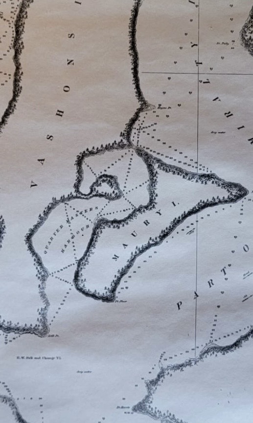
Wilkes named 261 islands, bays, and points in Puget Sound, thus strengthening the United States’ claim over the Oregon territory. Points and bays were named after his quartermasters, such as Beal, Robinson, Piner, and Quartermaster Harbor. One of his Captains was named Vashon, and Maury, being a separate Island, was named after the expedition’s astronomer, Lieutenant William Maury.
Captain Vashon used a telescope to view the survey crew on Piner Point, Vashon. Captain Wilkes ordered Captain Vashon to alert him of the flash from the muzzle of a mortar. The two officers were on Brown’s Point attempting to measure the distance to Piner Point using a pendulum.
The flash from the mortar was seen, and Captain Wilkes released the pendulum and counted the swings until the explosion from the mortar was heard. Captain Wilkes computed the distance using the time it took for the sound to travel between the two points, and found the distance to be one mile plus.
We were so taken by the ancient surveying, and the accuracy of the maps produced from the surveyor’s notes, that John and I decided to repeat one of the surveying techniques by duplicating the depth or soundings of Quartermaster Harbor between Jensen Point and Portage. We used Wilke’s chart to locate the line and the frequency of his soundings.
‘“Mark!” I hollered, and Seán dropped the lead line, knotted in fathoms and tenths of fathoms. “One and two” Seán replied, lifting the line back into our little “expeditionary” crab boat. He carefully noted the findings in a well-maintained notebook.
I did the navigation using a handheld GPS unit and some calculations of angles from known points in the Harbor. Seán took the notes, because his handwriting is distinct and legible.
I suppose this whole idea started with crabbing. We had been trying to locate our secret crab spot over a few years, and would probe the bottom with lead lines and record our findings. Success eventually came, as we precisely located a line to drop our pots and had great catches for a number of years.
All I can tell you is that we used a specific angle between a hidden meadow on Maury and a point near Lost Lake. If we told you anymore, then our secret spot would not be secret.
On one of our first trips to set pots, we took Seán’s two rambunctious dogs and pulled four pots, with a load of keepers in each one. Well, a release failed on one pot, and crabs invaded the bottom of the boat, which resulted in the dogs fending off nasty pinchers. Inevitably, the dogs knocked over one of our buckets full of crabs, which released another batch of angry mayhem.
That and the rather reluctant starting outboard made for a hazardous trip back to the marina, where we eventually sorted it all out, but the dogs were not invited on any further crab trips.
Our idea of retracing the old Wilkes soundings came about as we wondered if the depth of the inner harbor had changed much in 180 years, as there had been some debate as to whether the Portage cut had allowed much exchange of water in and out of Quartermaster. We thought it would be a good diversion to actually see and compare.
Seán wrote a good analysis of how the expedition measured distance and location. Much of what they did, we repeated, such as correcting for tides, but the calculations were much easier for us than with the tools available to the Wilkes expedition.
As it turned out, we found little difference between our results and theirs. It is interesting to see how the Ex. Ex. conducted their survey, which took immense coordination on boats and shore, using what must have amounted to many seamen.
Naturally, the Wilkes seamen used bigger boats and probably took their dogs with them. Even after extensive perusal of the original notes, we find a distinct absence of data in the area of our “secret” crabbing spot, and we are not telling!